I have always had a thing for maps. I like to look at them and see the little details embedded in them. In our dining room we have a National Geographic map mounted and framed of the world in 1939, just before WWII. I will stand there and notice all the different information contained on that sheet of paper and am amazed.
Maps can tell you many things about the world, your country, your state, even your town. Things you never knew about the very place you live shows up on maps. Look through historical maps of your area and you will find ghost towns, businesses that are no more, or even how your town grew over the years.
When I am reading books about war, it helps to have the maps of the area available to be able to trace the movements of the units. I find them essential in helping me understand the nuances of the battle, unit movements, significant actions. I find it really annoying when more maps are not put into the books or if the ones that are enclosed are not of significant detail.
So onto a few I have found recently that really intrigued me:
The map above shows the areas of the world you can use Google Street View function in Google Maps. Notice the most part of Asia, great part of Russia, and the majority of Africa and Canada are black.
I found this interesting showing the land usage in the continental United States.
This is a map of North Korea around the Chosin Reservoir. I was reading a book called "One Trumpet No Drums" about the 1st Marine Division and the pull back from the area and really needed this map while reading so I could track the movement of the units. Of course, I did not have it and had to use Google Maps to sort things out (sort of). A friend I lent the book to found this map and sent it to me. Of course, I re-read the book with the aid of the map and it was much more informative.

I used to work for a shipyard, Colonnas Shipyard, in Norfolk Va. It is the oldest family owned shipyard in the United States having started in 1875 or so. I found this old map and found that shipyard on it! Notice the second bridge from the right....that cluster of ships. That is where Colonnas started. Started out simply with a single railway type ship hauler. Now has 1 railway (used primarily to haul barges out), three floating drydocks, and what used to be the largest travellift. It can haul out a vessel up to 1000 tons. That monster services 15 other "gray beams" with small Navy ships, tug boats, barges....about anything really. We counted up the number of vessels that could be "parked" at Colonnas once...over 28 ships at one time! Not to bad for a small family owned shipyard!
The population in the red areas exceeds the population in the grey. Amazingly enough, the red areas pretty much damned near mirrors the Democrats base.
If the states were sized by their populations. I need to be in one of those upper mid west states (Wyoming, Montana, South Dakota, North Dakota) instead of "California on the East Coast" Virginia.
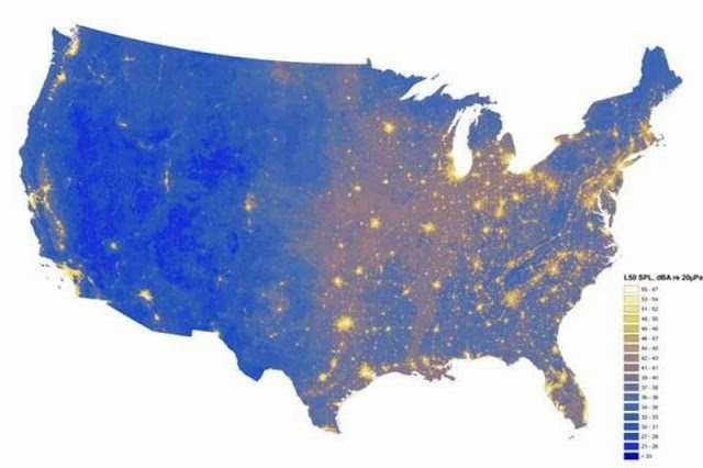
Add this map to the one above. This map shows the "nosiest" places in the US. Please note the states I talked about above are some of the quietest. Hmmmm
Pretty cool map of the status of land and forces before WWI began.


